

2:LOCATION + NEIGHBORHOOD FABRIC
Locating the project in a neighborhood with existing infrastructure, transportation and services enhances livability, leads to more resource-efficient development of land, saves energy, and increases the vitality of the community.
2.1
Mandatory
Sensitive Site Protection
RATIONALE
Protecting fragile and scarce environmental resources minimizes negative impacts on valuable ecosystems. Designating sensitive lands into Ecological Resource Protection Zones (ERPZs) and limiting development in these areas decreases the impact that development has on fragile ecosystems and reduces the risks of flooding due to climate change.
REQUIREMENTS
All projects must:
-
Protect floodplain functions (e.g., storage, habitat, water quality) by limiting new development within the 100-year floodplain of all types of watercourses.
-
Conserve and protect aquatic ecosystems, including wetlands and deepwater habitats that provide critical ecosystem functions for fish, other wildlife, and people.
-
Protect ecosystem function by avoiding the development of areas that contain habitat for plant and animal species identified as threatened or endangered.
-
Conserve the most productive agricultural soils by protecting prime farmland, unique farmland, and farmland of statewide or local importance.
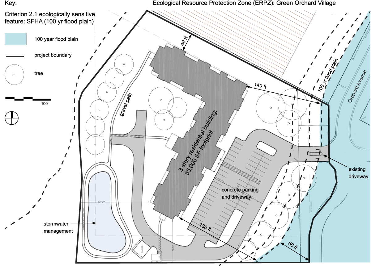
If your site contains any of these ecologically sensitive features (floodplains: aquatic ecosystems, including wetlands; habitat for threatened or endangered species; prime farmland), follow the Requirements under that subheading.
An ERPZ requires boundaries that are identified and mapped on site plan(s) during the pre-development phase. Areas that fall inside the perimeter of an ERPZ must be treated sensitively, as described through- out the Enterprise Green Communities Criteria, to ensure that there is no disturbance, disruption, or damage of: 1) floodplains; 2) aquatic ecosystems, 3) wildlife habitats; and 4) prime farmland. Not every development will have an ERPZ. A development that has an ERPZ will not necessarily have each of the four ERPZ types represented.
1. Protect floodplain functions
Protect floodplain functions (e.g., storage, habitat, water quality) by limiting new development within the 100-year floodplain of all types of watercourses. To determine if you’re in a Special Flood Hazard Area (SFHA), refer to the FEMA Flood Map Center (https://msc.fema.gov/portal/home) or other local/state agency, as appropriate.
- All projects must document the location of the 100-year floodplain as identified by FEMA on the Flood Insurance Rate Map (FIRM) as part of an ERPZ. See sample ERPZ documentation above:
New Construction—Minimize development in floodplains:
- Do not develop on a site that contains any SFHA as identified by FEMA on the FIRM, or local/state entity as appropriate.
Rehabilitation—Maintain or improve existing floodplain conditions:
- Projects built on land that is within the SFHA as identified by FEMA on the FIRM, must be designed to meet the ASCE 24 Flood Resistant Design and Construction standard.
-
Ensure that any development or redevelopment activities within the floodplain will mitigate and improve existing floodplain conditions (maintain or increase existing floodplain storage, improve water quality, implement flood-resilient design).
-
Do not raise topographical elevations in flood zones.
2. Protect aquatic ecosystems
All projects must document the full geographic extent of any aquatic ecosystems, including isolated wetlands, located within the project boundary as part of an ERPZ. (See sample ERPZ documentation on previous page.)
Aquatic ecosystems include wetlands and deepwater habitats, and are classified as:
-
Marine (tidal wetlands, shorelines, mudflats, reefs)
-
Estuarine (bays, lagoons, marshes)
-
Riverine (streams, rivers [associated floodplains and their riparian buffer])
-
Lacustrine (lakes, ponds [associated shorelines and their riparian buffer])
- Palustrine (non-tidal wetlands, seeps, springs, vernal pools, seasonal wetlands)
Identifying and delineating aquatic ecosystems is detailed by the U.S. Army Corps of Engineers. Other boundaries of aquatic ecosystems are defined by ordinary high-water mark (OHWM).
New Construction. Do not build within 100 feet of any of the wetlands or deepwater habitats identified in the ERPZ.
Rehabilitation. Maintain or improve existing aquatic ecosystems:
-
Do not extend the building, built structures, roads, or parking areas into the ERPZ, beyond where they already exist.
-
Develop restoration plans for wetland and deepwater habitats within the ERPZ.
3. Conserve habitat for any species on federal or state threatened or endangered lists
As part of the pre-development design process, identify whether the site is in the range of habitats for any plant or animal species on U.S. federal or state threatened or endangered lists. If the site hosts any threatened or endangered plant or animal species, conduct a habitat assessment for each identified species.
All Projects. Sites that feature habitats for any species on federal or state threatened or endangered lists must:
-
Designate the full extent of habitats for threatened and endangered plant and animal species on the site as an ERPZ and do not extend the building, built structures, roads, or parking areas into the ERPZ. (See sample ERPZ documentation above.)
-
Minimize disturbances within the ERPZ during construction. If construction activities permanently disrupt the habitat of threatened or endangered animal habitats, follow the guidance of responsible state (or local) agencies on how to best address.
4. Limit development on farmland (only for New Construction projects)
Prime farmland is defined by the U.S. Department of Agriculture (USDA) in the United States Code of Federal Regulations, Title 7, Volume 6, Parts 400–699, Section 657.5 or by the USDA’s Natural Resources Conservation Service (NRCS) soil survey.
If farmland soils are present on-site, consider relocating the project to an alternative site. If developing on an alternative site is not possible:
-
Designate the full extent of prime farmland soils on the site as an ERPZ (see sample ERPZ documentation on page 41). Minimize development and disturbance of prime farmland. Note the percentage of prime farmland that is developed.
- If more than 20% of the prime farmland noted in the ERPZ is developed, the project must purchase a permanent agricultural conservation easement on land with comparable, productive farmland soils for every acre of prime farmland developed, 1:1.
RECOMMENDATIONS
-
Operations and Maintenance plans (Criterion 8.1) should include section(s) describing ongoing management activities required to protect the integrity of the floodplain functions.
-
Many states have specific protocols for evaluating sites for endangered animals and plants. Be sure to consult with your state (or local) codes or other requirements when evaluating the wildlife habitats on your site.
- When endangered animal species are present on-site, make efforts to commence construction and maintenance activities during seasons when the animal species are not present.
RESOURCES
-
U.S. Departments of Homeland Security, FEMA Flood Map Service Center. https://msc.fema.gov/portal/home
-
U.S. Army Corps of Engineers, Regional Supplements to Corps Delineation Manual. www.usace.army.mil/Missions/Civil-Works/Regulatory-Program-and-Permits/r...
-
U.S. Department of Agriculture, Natural Resources Conservation Service—Soil Survey. www.nrcs.usda.gov/wps/portal/nrcs/detailfull/soils/survey/?cid=nrcs142p2...
-
U.S. Department of Agriculture, Wetland Restoration, Enhancement, and Management (2003). https://www.nrcs.usda.gov/Internet/FSE_DOCUMENTS/nrcs143_010838.pdf
-
U.S. Department of the Interior, Fish and Wildlife Service—Endangered Species (plants and animals): www.fws.gov/endangered/. For an interactive online map of critical habitat for threatened and endangered species: https://fws.maps.arcgis.com/home/webmap/viewer.html?webmap=9d8de5e265ad4...
-
U.S. Department of Agriculture, A Technical Guide for Monitoring Wildlife Habitat (2013). www.fs.fed.us/research/publications/gtr/gtr_wo89/gtr_wo89.pdf
-
Federal Geographic Data Committee, Classification of Wetlands and Deepwater Habitats of the United States. www.fgdc.gov/standards/projects/wetlands/nwcs-2013
-
Farmland Information Center. www.farmlandinfo.org
-
American Farmland Trust. https://farmland.org/
Mandatory for New Construction, except for projects defined as Rural/Tribal/Small Town
Connections to Existing Development and Infrastructure
RATIONALE
Locating a project within an existing neighborhood and in proximity to existing infrastructure encourages more resource-efficient development of land, conserves energy, adds to the vitality of the overall community, and safeguards a community during significant weather events. Ensuring that pedestrian and cycling infrastructure is included encourages safe, active transportation, which can improve health by increasing daily physical activity.
REQUIREMENTS
-
Locate the project on a site that is within or contiguous to existing development (at least 25% of the site perimeter borders currently developed land) and that has access to existing road, water, and sewers infrastructure.
-
Connect the project to the existing pedestrian network by creating new roads with sidewalks, providing sidewalks on existing streets, or providing all-weather pathways to link the project to transit stops, public or civic spaces, open spaces, and adjacent development.
-
For sites over 5 acres, provide connections to the adjacent street network at least every 800 linear feet along site perimeter.
- Tie all planned bike paths/lanes on your site to existing bike paths or lanes that intersect your site in ways that are safe, accessible, and clearly identified.
RECOMMENDATIONS
-
Provide enhanced pedestrian crossings at intersections using elements such as curb extensions, medians, crosswalk count-down clocks, daylighting, detectable warning strips, street treatments (e.g., different color or texture pavement in crosswalks), or sidewalk expansion. On streets with large blocks, consider mid-block pedestrian crossings.
-
Dedicated pedestrian and bicycle paths are important even on dead-end streets.
-
If bicycle lanes or paths run through or adjacent to your site, consider adding bicycle storage for residents and visitors.
- Design engaging and safe sidewalk experiences appropriate for expected pedestrian flows and uses. Include benches and shade trees for rest and shade.
RESOURCES
-
Task Force on Community Preventive Services, The Community Guide—What Works to Promote Health. www.thecommunityguide.org/
-
Center for Active Design, Active Design Guidelines. Includes a chapter on urban design (Chapter 2) highlighting best practices for sidewalk design to encourage their vibrant use, including features like trees, lighting, and wayfinding. https://centerforactivedesign.org/guidelines/
-
Center for Active Design, Healthy Housing for All. https://centerforactivedesign.org/healthy-housing-for-all
-
NYC Department of Health and Mental Hygiene, Active Design Supplement: Shaping the Sidewalk Experience (2013). www1.nyc.gov/assets/doh/downloads/pdf/environmental/sidewalks-experience.pdf
-
NYC Department of Health and Mental Hygiene. Active Design Supplement: Active Design Promoting Safety (2013). www1.nyc.gov/assets/doh/downloads/pdf/environmental/promoting-safety.pdf
-
The Community Preventive Services Task Force. Environmental and Policy Approaches to Increase Physical Activity, Street-Scale Urban Design Land Use Policies. www.thecommunityguide.org/findings/physical-activity-built-environment-a...
-
Smart Growth America, Complete Streets. www.smartgrowthamerica.org/complete-streets
-
Resilient City Urban Design Principles. A resilient post-carbon community, which reorients city-life to the pedestrian scale (a 500-mile radius), must focus its efforts on creating several
local destinations, which attract a critical mass of users and activities. www.resilientcity.org/index.cfm?id=11928
Mandatory for New Construction
Compact Development
RATIONALE
Compact development encourages more resource-efficient development of land, conserves energy and supports demand for transit, neighborhood retail and community cohesion. Compact development also correlates with walking behavior and physical activity through active transportation. For communities that want to promote active transportation and a healthy lifestyle, compact development is critical to success.
REQUIREMENTS
At a minimum, build to the residential density (dwelling units / acre) of the census block group where the project is located. Find the density of your census block group by typing your project address into the Center for Neighborhood Technology “Residential Density of a Location” calculator found at http://apps.cnt.org/residential-density.
In Rural/Tribal/Small Town locations that do not have zoning requirements: Build to a minimum net density of 5 units per acre for single-family houses; 10 units per acre for multifamily buildings, single and two-story; and 15 units per acre for multifamily buildings greater than two stories.
Notes:
-
Net density calculations do not include land that is set aside for future building phases or development. For multi-phased projects, the project net density should include only the portion of the parcel that is being used for that particular phase.
-
Any acreage maintained as permanently protected open space per Criteria 2.6 and 2.7 may be deducted from total project acreage to determine project density.
RECOMMENDATIONS
To determine if your project qualifies as Rural/Tribal/Small Town, reference the definitions included in the Appendix.
RESOURCES
-
Congress for the New Urbanism. This nonprofit organization provides tools and resources for promoting walkable, neighborhood-based development as an alternative to sprawl. www.cnu.org
-
Smart Growth America. This website outlines smart growth principles, provides a guide through smart growth terms and technical concepts, and hosts a searchable catalogue of reports, websites, tools, and case studies. https://smartgrowthamerica.org/
-
Resilient City Urban Design Principles. A resilient post-carbon community, which reorients city life to the pedestrian scale (a 500-mile radius), must focus its efforts on creating several local destinations, which attract a critical mass of users and activities. www.resilientcity.org/index.cfm?id=11928
-
Urban Land Institute. This nonprofit organization promotes the responsible use of land to enhance the total environment. ULI’s online bookstore includes numerous publications regarding compact and higher-density development. www.uli.org
Optional | 5 or 7 points
Increased Compact Development
RATIONALE
Compact development encourages more resource-efficient development of land, conserves energy and supports demand for transit, neighborhood retail, and community cohesion. See Rationale for Criterion 2.3.
REQUIREMENTS
Exceed the residential density (dwelling units/acre) of the census block group in which your project is located. Find the density of your census block group by typing your project address into the Center for Neighborhood Technology “Residential Density of a Location” calculator found at http://apps.cnt.org/residential-density/.
In Rural/Tribal/Small Towns that do not have zoning requirements, build to a minimum net density of 7.5 units per acre for single-family houses; 12 units per acre for multifamily buildings, single and two-story; and 20 units per acre for multifamily buildings greater than two stories. [5 points]
|
EXCEED THE CNT RESIDENTIAL DENSITY |
OPTIONAL POINTS |
|
2x |
5 points |
|
3x |
7 points |
RECOMMENDATIONS
See Recommendations for Criterion 2.3.
RESOURCES
See Resources for Criterion 2.3.
2.5
Mandatory for New Construction
Proximity to Services and Community Resources
RATIONALE
Locating housing in proximity to neighborhood services, including grocery stores, community centers, health services, and some retail shops, reduces the need to travel, thus reducing monthly living costs and improving health by encouraging walking or biking. Additionally, proximity and access to active recreation facilities such as parks, playgrounds, and other exercise amenities are associated with increased physical activity and contribute to a healthy lifestyle.
Residents with services within a close, safe, accessible physical proximity will fare better during natural disasters in the event of a loss of automobile access or other major events when gasoline and public transportation may be limited.
REQUIREMENTS
Demonstrate that your project is within a 0.5-mile walk distance of at least four, or a 1-mile walk distance of at least seven, resources identified below.
For projects that qualify as Rural/Tribal/Small Town, locate your project within 5 miles of at least four services.
Each “service” type may not be counted more than twice. For example, if there are five banks within the required distance, only two may be counted.
SERVICES AND COMMUNITY RESOURCES
|
FOOD ACCESS |
HEALTH & WELLNESS |
EDUCATION & CULTURE |
MOBILITY |
CIVIC & COMMUNITY FACILITIES |
RETAIL |
SERVICES |
|
|
|
|
|
|
|
RECOMMENDATIONS
-
To determine if your project qualifies as Rural/Tribal/Small Town, reference the definitions in the Appendix.
-
In conversations with existing (or potential) residents, and using other assessment tools like the Enterprise Opportunity Report (Opportunity360), identify the most needed services and community resources in your area.
-
Make the pedestrian experience safe and comfortable. Consider using some of the following techniques to make pedestrian paths more enjoyable and accessible: tactile curb warning ramps, additional pedestrian-scale lighting, clearly marked crosswalks, corner bulb outs, sidewalk benches, street trees/plantings, and pedestrian crossing signals.
- City, municipal, and county governments (e.g., local planning department, health department) can serve as valuable resources to better understand community amenities.
RESOURCES
-
Walkscore. www.walkscore.com/
-
Google Maps offers a function to demonstrate walk distance. On Google Maps, go to “Directions” and select “Walk Directions” to obtain this information. www.google.com/maps
-
Safe Routes to School National Partnership. This network of more than 300 nonprofit organizations, government agencies, schools, and professionals works to advance the Safe Routes to School (SRTS) movement in the United States. SRTS can provide a variety of important benefits to children and their communities, including increasing physical activity, reducing traffic congestion, improving air quality, and enhancing neighborhood safety. www.saferoutespartnership.org/home
-
Resilient City Urban Design Principles. A resilient post-carbon community, which reorients city life to the pedestrian scale (a 500-mile radius), must focus its efforts on creating several local destinations, which attract a critical mass of users and activities. https://www.resilientcity.org/index.cfm?pagepath=Resilience/Urban_Design...
-
The National Association of Area Agencies of Aging (n4a). This resource can be used to find aging-in-place service providers in your area. www.n4a.org/
-
U.S. Department of Health and Human Services, U.S. Administration on Aging, Eldercare Locator. This resource can be used to find home- and community-based service providers in your area. https://eldercare.acl.gov/Public/Index.aspx
-
Consider using a technology like TransitScreen in your building’s common space(s) to provide real-time transportation information to building residents and staff. http://transitscreen.com
-
University of Washington, College of Built Environments, Department of Architecture. Professor Anne Vernez-Moudon’s papers on walkability. http://arch.be.uw.edu/people/anne-vernez-moudon/
Mandatory for New Construction Rural/Tribal/Small Town
Preservation of and Access to Open Space for Rural/Tribal/Small Town
RATIONALE
Open space is more than just a land asset for development; it is an amenity that attracts and welcomes the broader community. Access to safe open space and other natural resources improves quality of life, enhances opportunities for physical activity and social interaction/connection, and provides the opportunity to better understand the natural ecosystem and regional identity.
REQUIREMENTS
Option 1
Locate the project within a 0.25 mile walk distance of dedicated, public open space that is a minimum of 0.75 acres and is open and accessible to all residents. A minimum of 80% of the public open space must be non-paved.
OR
Option 2
Set aside a minimum of 10% (minimum of 0.25 acre) of the total project acreage as permanent open space that is open and accessible to all residents. A minimum of 80% of the open space must be non-paved.
Notes (for all options):
- When calculating open space, be sure to deduct buildings, private outdoor areas, streets/roadways and vehicle parking from your total site area.
-
Green roofs can be used in open space calculations if the roof area is accessible to all residents.
- Land that is set aside for future development cannot be included as open space in these calculations.
RECOMMENDATIONS
-
To determine if your project qualifies as Rural/Tribal/Small Town, reference the definitions in the Appendix.
-
Be sure to consider security and maintenance of all open spaces included on-site.
-
Design building massings to enhance nearby parks, plazas, and open spaces.
-
Open spaces should be safe and designed to promote active use by residents. Features such as active bike and walking trails/paths, lighting, seating options, native plantings and recreation facilities make open spaces a community amenity.
- Open spaces should complement the cultural preferences of the local population and accommodate people of all ages.
RESOURCES
-
U.S. Environmental Protection Agency, Smart Growth and Open Space Conservation. https://www.epa.gov/smartgrowth/smart-growth-and-open-space-conservation
-
The Trust for Public Land. Creates parks and protects land for people, ensuring healthy, livable communities for generations to come. www.tpl.org
-
The Trust for Public Land, ParkScore Index. A rating system developed to measure how well U.S. cities are creating parks. https://www.tpl.org/parkscore
Optional | 6 points maximum
Preservation of and Access to Open Space
RATIONALE
See Rationale for Criterion 2.6.
REQUIREMENTS
Option 1
Locate the project within a 0.25-mile walk distance of dedicated, accessible public open space that is a minimum of 0.75 acres. A minimum of 80% of the public open space must be non-paved. [4 points]
OR
Option 2
Set aside a percentage of permanent open space for use by all residents; at least 80% of which unpaved.
|
PERCENTAGE OF OPEN SPACE SET ASIDE |
NUMBER OF OPTIONAL POINTS |
|
25% |
2 points |
|
35% |
4 points |
|
45% + submitted written statement of preservation/ |
6 points |
Notes (for all options):
-
When calculating open space, be sure to deduct buildings, private outdoor areas, streets/roadways, and vehicle parking from your total site area.
-
Green roofs can be used in open space calculations if the roof area is accessible to all residents.
- Land that is set aside for future development cannot be included as open space in these calculations.
RECOMMENDATIONS
See Recommendations for Criterion 2.6.
RESOURCES
See Resources for Criterion 2.6.
2.8
Mandatory for New Construction except for projects defined as Rural/Tribal/Small Town Optional for all other projects | 2, 6, or 8 points
Access to Transit
RATIONALE
Projects located near transit reduce a resident’s need to own or rely upon a car, thereby eliminating or lowering the costs of auto ownership. Transit use and biking reduces consumption of fossil fuel and related emissions of air pollutants and carbon dioxide. In addition, locating near high-frequency transit typically allows project residents to access major employment centers, and can provide opportunities for increased physical activity through active transportation, improving health. Bicycle facilities can significantly increase the area served by public transit, as distances too long to walk are often easily accessible by bicycle.
REQUIREMENTS
New Construction not in Rural/Tribal/Small Town Locations
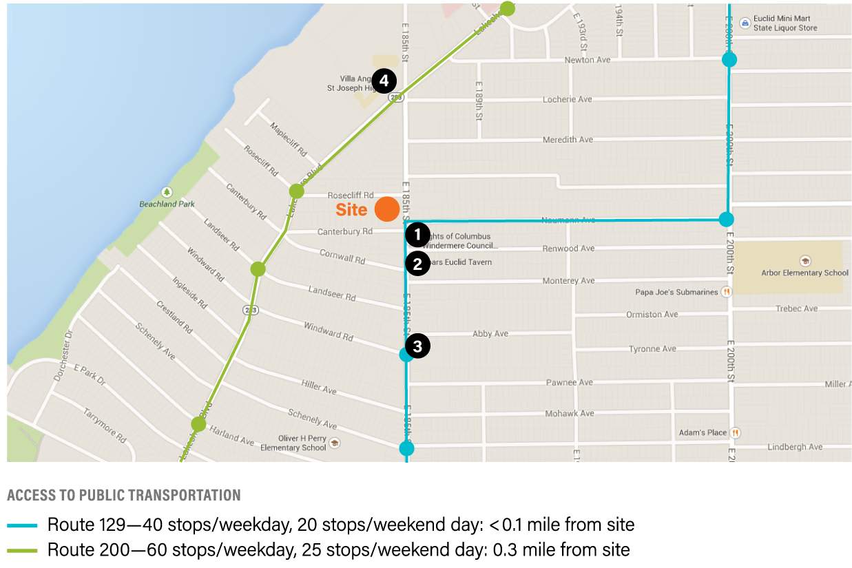
- Mandatory: Locate projects within a 0.5-mile walk distance of public transit services (bus, rail, and/or ferry) that combined constitute at least 45 or more transit rides per weekday and include some type of weekend service.
- Optional: Locate the project along dedicated bike trails or lanes (Class I, II or IV) that lead to high-quality transit services (100 or more trips per day) within 3 miles. [2 points]
Rehabilitation Projects not in Rural/Tribal/Small Town Locations
- Optional: Locate projects within a 0.5-mile walk distance of public transit services (bus, rail, and/or ferry) that combined constitute at least 45 or more transit rides per weekday and include some type of weekend service. [6 points]
- Optional: Locate the project along dedicated bike trails or lanes (Class I, II or IV) that lead to high-quality transit services (100 or more trips per day) within 3 miles. [2 points]
New Construction and Rehabilitation Projects in Rural/Tribal/Small Town Locations
Optional: Locate the project within a 0.5 mile walk distance of public transit services (bus, rail, and/ or ferry) that combined constitute at least 45 or more transit rides per weekday and include some type of weekend service. OR, install at least two charging stations for electric vehicles on the project site. OR, locate the project within 5 miles of one of the following transit options: 1) vehicle share program; 2) dial-a-ride program; 3) employer vanpool; 4) park-and-ride; 5) public/private regional transportation. [6 points]
RECOMMENDATIONS
A “ride” is an opportunity to take a transportation line or route from a stop. For example, if your site has one bus stop that services two bus routes that each run service every 30 minutes from 6 a.m. to 9 p.m., your project would have:
Route 1: 15 hours x 2 stops per hour = 30 “rides”
+ Route 2: 15 hours x 1 stop per hour = 15 “rides”
Total: 45 rides/workday
Many cities and counties provide bicycle trail and route maps for free download on their websites.
RESOURCES
-
To determine if your project qualifies as Rural/Tribal/Small Town, reference the definitions in the Appendix.
-
Google Maps offers a function to demonstrate walk distances and to identify bicycle trail and route maps. On Google Maps, go to “Get Directions” and select “Walking” or “Bicycling,” as applicable, to obtain this information. www.google.com/maps
-
Consider using a technology like TransitScreen in your building’s common space(s) to provide real-time transportation information to building residents and staff. http://transitscreen.com/
-
Victoria Transportation Policy Institute. This independent research organization provides consulting and publicly available research about solutions to emerging transportation issues, such as transportation demand management. www.vtpi.org
-
National Center for Mobility Management, Profiles of Innovative Rural Vanpool Programs. This resource describes several exceptional vanpool programs around the country. https://ncmm.aura-software.com/vanpooling/
-
The City of Oakland California, Engineering and Construction—Bikeway Types. This resource is helpful to better understand the differences between Class I, Class II and Class IV bike lanes. http://www2.oaklandnet.com/government/o/PWA/o/EC/s/BicycleandPedestrianP...
-
National Association of City Transportation Officials, Bike Lanes. http://nacto.org/cities-for-cycling/design-guide/bike-lanes/
Optional | 2–8 points
Improving Connectivity to the Community
RATIONALE
Connections to adjacent development and public, open spaces promote recreational walking, biking and alternative means of commuting as well as other healthy lifestyle choices. Safe and accessible connections to amenities and open space can reduce isolation and increase equity by making it easier for residents to access community amenities, including transit. Research shows that low-income communities and communities of color often do not have access to these benefits, and this has led to lower levels of physical activity and high rates of chronic diseases, as well limited access to quality jobs. Increasing access to safe, complete sidewalks, bike paths, open spaces and community amenities is a step toward reducing inequities created by our built environment.
REQUIREMENTS
Improve access to community amenities through at least one of the measures below. To earn optional points under this criterion, projects achieve at least 2 points.
Incentivize Biking Mobility
- Provide outdoor bicycle racks that are accessible for visitors and residents. [1 point]
-
Provide secure, lockable, sheltered, and accessible bicycle storage. Provide at least one bicycle parking space for every residential unit. Post signage directing residents to bicycle parking areas and programs. [2 points]
-
Provide bicycles and equipment (e.g., helmets, locks, tire pumps, maintenance equipment) for resident use. [4 points]
-
Promote use of, and access to, one or more bicycle-share/micro-mobility (scooter) programs within 0.25-mile of the building. Bicycles and scooters need to be accessible to occupants at all hours. Maps to the nearest bike station and scooter docking facility should be posted in a visible location within a common area in the building and included in the Resident Manual (Criterion 8.3). [2 point]
-
Provide residents with discounted bicycle-share/micro-mobility (scooter) memberships for a period of at least 12 months. [2 points]
-
Provide residents with free bicycle-share memberships for a period of at least 12 months. [4 points]
Improving Access
-
Provide residents with discounted transportation passes for a period of at least 12 months. [2 points]
-
Provide residents with free transportation passes for a period of at least 12 months. [4 points]
-
Include car-share services (parking) on property. [1 point]
-
Provide all eligible residents with discounted car-share memberships for a period of at least 12 months. [2 points]
- Provide a minimum of 50% of eligible residents with free car-share memberships for a period of at least 12 months. [4 points]
RECOMMENDATIONS
-
When considering enhancing access to alternative modes of transportation, gather community input to learn what they would see as benefiting their community.
-
Safety should be encouraged when considering opportunities for biking, walking, driving, and parking. Consider promoting designs that encourage slow-speed, low-volume roadways, thereby enhancing pedestrians’ and bikers’ safety.
-
Provide orientation materials and maps to the nearest bus, transit stations, and car-share or bike- share facilities (general orientation materials are acceptable for floating car- or bike-share services). Information about these amenities should be posted in a visible location in a common area in the building and included in the Resident Manual (Criteria 8.3).
-
Consider offering a credit for residents to try their local car-share or bike-share service (if available). Contact the provider of these services to see if they would like to offer a discount or credit to encourage use.
-
Incorporate street trees and furniture such as benches, trash receptacles, and bicycle racks to create an active streetscape.
-
For ease of use, bicycle storage is ideally incorporated on the ground floor with direct roll-in access that is separate and distinct from automobile access. Push-button doors make roll-in access even more convenient for riders, especially during inclement conditions.
-
Provide bicycle storage for staff as well as residents.
-
Make bicycle and pedestrian routes to parks and public spaces safe and visible.
-
Provide shade for bicycle and pedestrian routes to protect residents from heat island effect and extend usage hours.
-
Conduct an assessment to determine most likely routes of pedestrian and bicycle use when laying out paved pathways/sidewalks from the project to the surrounding neighborhood. Build the pathways/sidewalks where there is visible evidence of pedestrian and bicycle use.
-
To encourage pedestrian activity, minimize vehicular curb cuts on streets with heavy foot traffic; construct curb extensions along sections of the sidewalk that tend to attract greater pedestrian congestion and that are close to pedestrian crossings.
-
Dedicated pedestrian and bicycle paths are important even on dead-end streets.
- Install street features that have been shown to effectively calm traffic, including curb extensions, medians, roundabouts, and raised speed-reducers.
RESOURCES
-
NYC Departments of City Planning, Health and Mental Hygiene, and Design and Construction. Active Design Supplement: Shaping the Sidewalk Experience (2013). http://www1.nyc.gov/assets/planning/download/pdf/plans-studies/active-de...
-
Robert Wood Johnson Foundation, Active Living Research. https://activelivingresearch.org/
-
Transportation for America, The Scenic Route: A primer on creative placemaking in transportation. www.americansforthearts.org/sites/default/files/Creative-Placemaking-Web...
-
Task Force on Community Preventive Services, The Community Guide: What Works to Promote Health. www.thecommunityguide.org/resources
-
Task Force on Community Preventive Services, The Community Guide: Street-Scale Urban Design Land Use Policies. www.thecommunityguide.org/sites/default/files/PA-Street-Scale-Archive.pdf
-
PolicyLink report on research and recommendations for Healthy Equitable Transportation Policy. www.policylink.org/sites/default/files/HEALTHTRANS_FULLBOOK_FINAL.PDF
Optional | 5 points maximum
Passive Solar Heating/Cooling
RATIONALE
The use of passive solar design minimizes need for mechanical heating, lowers cooling loads, and increases access to natural daylight. Passive solar heating, cooling-load avoidance strategies and a knowledge of prevailing winds are valuable in protecting the well-being of residents during extended power outages or interruptions in heating fuel.
REQUIREMENTS
Design and build project with passive solar design, orientation, and shading that meets the following guidelines.
|
PROJECT TYPE |
POTENTIAL POINTS |
REQUIREMENTS |
|
New Construction Stand-alone building |
5 |
Meet all guidelines |
|
New Construction |
2 3 4 5 |
25% of the homes meet all guidelines |
|
Rehabs Moderate or Substantial |
3 2 |
All new windows must comply with the glazing All south-facing elevations must comply with |
GUIDELINES
Glazing Types
At a minimum, provide windows that are ENERGY STAR Certified, and are appropriate to the climate zones outlined by ENERGY STAR. www.energystar.gov/products/building_products/residential_windows_doors_...
Orientation, Glazing Placement and Shading
- Building orientation. Orient the building so that the longer side faces within 15 degrees of north–south.
-
Glazing. Climate Zones 1–3: The glazing area on the north- and south-facing façades should be 50% greater than the sum of the glazing areas on the east- and west-facing walls; Climate Zones 4–7: The glazing area on the south-facing façade should be 30% greater than the sum of the glazing areas on the east-, west- and north-facing façades.
-
Shading. For south-facing windows, follow the shading requirements in the following table and the map in the Appendix.
Requirements for Shading
To find your Climate Zone, see IECC Climate Zone Map in the Appendix. As of August 2019, those requirements are as listed:
|
CLIMATE ZONE (IECC CLIMATE MAP) |
PERCENTAGE OF WINDOW THAT NEEDS TO BE SHADED BY JUNE 21 |
|
1, 2 |
95% |
|
3 |
75% |
|
4 except Marine |
75% |
|
4 Marine, 5, 6, 7, 8 |
50% |
Note: The glazing type (Guideline 1) and shading (Guideline 4) requirements refer to two different and distinct zones. The former, glazing type, refers to the map provided by ENERGY STAR for Performance Criteria for glazing; whereas the latter, shading, refers to the IECC Climate Zones.
RECOMMENDATIONS
-
Interior spaces requiring the most lighting and heating should be along the south face of the building.
-
Include a narrow floor plate (less than 40 feet), single-loaded corridors and an open floor plan to optimize daylight and natural ventilation by accommodating the natural ventilation of prevailing winds.
-
Thermal Massing, Climate Zones 2–7:
- Locate a material with high thermal mass on the southern portion of the house where sunlight hits during the heating season.
- Materials with thermal mass include brick, concrete, stone, water and any other high-density material.
-
Passive cooling strategies:
- Plant deciduous shade trees at the south façades.
- Maximize cross ventilation by installing operable windows at the leeward and windward sides of the building.
- Install light-colored roofing or coat existing roofs with light-colored elastomeric coatings.
RESOURCES
-
U.S. Department of Energy, Building Technologies Office, Passive Solar Heating and Cooling. http://energy.gov/energysaver/articles/tips-passive-solar-heating-and-co...
-
2018 IECC Climate Zones Map. A detailed map that shows Climate Zones zoomed into each state and county as well as the basic 2018 IECC Building Code requirements for each Climate Zone (see the Appendix).
-
U.S. Department of Energy, National Renewable Energy Laboratory, “Passive Solar Design for the Home,” Report #DOE/GO-102001-1105, February 2001. www.nrel.gov/docs/fy01osti/27954.pdf
-
U.S. Department of Energy, Passive Solar Design. www.energy.gov/energysaver/energy-efficient-home-design/passive-solar-ho...
-
Passive Solar Architecture, by David Bainbridge and Ken Haggard, Chelsea Green Publishing, 2011.
Optional | 6 points
Adaptive Reuse of Buildings
RATIONALE
The reuse of existing structures reduces landfill waste, reduces the need for new materials, and reduces pressure to develop undeveloped land. Adaptive reuse techniques extend the useful life of existing structures. Preserving and adapting existing buildings can help reinforce the unique sense of history of your community by retaining known built forms.
REQUIREMENTS
Rehabilitate and adapt an existing structure that was not previously used as housing. Design the project to adapt, renovate, or reuse at least 50% of the existing structure and envelope (includes exterior skin and framing and excludes window assemblies and non-structural roofing).
Projects with multiple buildings are eligible for optional points in this criterion so long as one of the buildings is being renovated and adaptively reused for residential purposes.
RESOURCES
- National Trust for Historic Preservation, Preservation Leadership Forum. Untapped Potential: Strategies for Revitalization and Reuse. https://forum.savingplaces.org/viewdocument/untapped-potential-strategie...
-
Municipal Research and Services Center of Washington, Infill Development Strategies for Shaping Livable Neighborhoods. This site contains an overview of strategies for encouraging and implementing infill development patterns. http://mrsc.org/Home/Explore-Topics/Planning/Development-Types-and-Land-...
-
Center for Community Progress. This website provides information, resources, tools and assistance to support vacant property revitalization efforts. www.communityprogress.net
-
Eight Strategies for Cities Trying to Promote Adaptive Reuse of Buildings (June 2018). https://brownfieldlistings.com/blog/post/eight-strategies-for-cities-try...
-
10 Principles for ReUrbanism: Reuse and Reinvestment in the 21st Century. https://forum.savingplaces.org/blogs/forum-online/2016/09/07/ten-princip...
Optional | 6 points
Access to Fresh, Local Foods
RATIONALE
Access to fresh produce offers healthy food options for residents, and purchase of fresh produce directly from farmers demystifies the cycle of food production. This measure also supports local economic development that increases the economic value and production of farmlands and community gardens. An ability to obtain local food offers important resilience benefits should major U.S. agricultural areas in the Midwest and California be threatened, for instance.
REQUIREMENTS
Option 1: Neighborhood Farms and Gardens
Provide permanent space for food growing within the project site that is equal or greater in size to 10 square feet per dwelling unit for 50% of the dwelling units. Provide watering systems, secure storage space for tools, and safe access for residents to the gardening spaces. Ensure that the gardens are built and maintained in a manner to minimize pests through nontoxic methods such as Integrated Pest Management practices. Ensure that the food-growing space is managed by an entity that includes residents in its decision-making, such as a resident council/committee or homeowners’ association.
OR
Option 2: Community-Supported Agriculture
Offer a specified location within the project boundaries for delivery of community-supported agriculture (CSA) or fresh food share program shares for residents, project staff, and surrounding community members, as appropriate. Shares must be delivered to the specified delivery point on a regular schedule at least twice a month for at least four months of the year.
OR
Option 3: Proximity to Farmers Market
Locate the project’s geographic center within a 0.5-mile walk distance of an existing or planned farmers market that will operate at least once a week for at least five months of the year, or for a length of time proportional to the growing season for the project’s vicinity. A planned farmers market must have firm commitments from vendors that the market will meet all of the above requirements and be in full operation by the time there is 50% occupancy of the project’s dwelling units.
RECOMMENDATIONS
-
For projects pursuing Option 1, consider bringing in an individual or a group (e.g., a master gardener or a garden club) to work with the residents to establish the garden and maintain productivity.
-
For projects pursing Option 1, consider allocating additional square footage for support areas for community gardening (i.e., pathways, sheds, storage areas).
-
Grow and/or plant foods that have cultural connection for residents—either familiar or traditional foods—and/or allow residents to decide what to grow. Plantings may also include food-bearing shade trees and ornamental shrubs.
-
Encourage fresh food providers, including those who organize farmers markets and run food cooperatives (co-ops), to accept Electronic Benefit Transfer (EBT) and Supplemental Nutrition Assistance Program (SNAP).
- Incorporating cooking classes for residents into your resident engagement program (see Category 8: Operations, Maintenance + Resident Engagement) is an excellent way to incentivize residents to eat healthy and prepare meals with fresh foods. Cooking classes are a fun and creative way to raise awareness and understanding of cultural diversity in a place, as well as a way to build community/social cohesion within a development.
RESOURCES
-
Local Harvest. This website offers a search function to find farmers markets, family farms and other sources of local, sustainably grown food in a given area. www.localharvest.org
-
U.S. Department of Agriculture, National Agricultural Library, Food and Nutrition Information Center, Community Food Systems. This website links to dozens of publications, programs and other sites. https://www.nal.usda.gov/fnic/community-food-systems
-
U.S. Department of Agriculture, Economic Research Service. The USDA, Treasury Department and HHS have defined a “food desert” as a census tract with a substantial share of residents who live in low-income areas that have low levels of access to a grocery store or healthy, affordable food retail outlet. Use this resource to determine if your project is located in a food desert. www.ers.usda.gov/data-products/food-access-research-atlas/go-to-the-atla...
-
Centers for Disease Control and Prevention, Community Food Assessment. The purpose of a community food assessment (CFA) is to determine the locations and incidence of food deserts—that is, areas with limited access to healthy and fresh food—and inform decision-makers of those areas that need intervention. www.cdc.gov/healthyplaces/healthtopics/healthyfood/community_assessment.htm
-
The Grocery Gap, Who Has Access to Healthy Food and Why it Matters. The Food Trust and PolicyLink, 2016. http://thefoodtrust.org/uploads/media_items/grocerygap.original.pdf
Optional | 8 points
Advanced Certification: Site Planning, Design and Management
RATIONALE
Project teams that have certified projects to these advanced site standards have taken steps to minimize the environmental impact of land development practices and emphasize themes of responsible land use, smart growth, urbanism and green building.
REQUIREMENTS
Locate building(s) within a community that is certified in one the following programs:
-
LEED for Neighborhood Development
-
LEED for Cities and Communities
-
Living Community Challenge
-
SITES
RESOURCES
-
U.S. Green Building Council, LEED for Neighborhood Development. This page has links to the LEED-ND rating system, a project checklist, and information on certification. www.usgbc.org/leed#rating
-
LEED for Cities and Communities. This page has a good breakdown of how the program works and how to certify, and a list of cities already registered to become a LEED City or Community. https://new.usgbc.org/leed-for-cities
-
Living Community Challenge. This page brings you to key resources of the program.
-
SITES. This page provides SITES certification overview and links to resources.
www.sustainablesites.org/certification-guide
2.14
Optional | 6 points maximum
Local Economic Development and Community Wealth Creation
RATIONALE
Housing can offer opportunities to directly enhance the lives of residents when it includes physical space to accommodate various programs for learning, job skill development, and other social interactions. Numerous studies have documented the ways in which affordable housing projects have positive economic impacts on their surrounding neighborhoods. In some cases, small business focused economic development can help mitigate displacement of local-owned businesses, retaining employment opportunities.
REQUIREMENTS
Demonstrate that a local preference for construction employment and subcontractor hiring was part of your bidding process.
Notes:
-
“Local preference” is defined as preference for any individual who resides within 25 miles of the project site.
-
Indian Preference can be solely that, without a miles-to-project requirement.
AND/OR
Option 2: Local Employment [3 points]
Demonstrate that you achieved at least 20% local employment.
To determine the percentage of local employment, calculate:
(Total # of hours worked by local individuals/Total # of hours on the project) x 100 = % of local employment
Notes:
-
If sweat equity hours were used to complete some of the labor for the project, those hours are eligible and should be included in the above calculation.
-
“Local employment” is defined as any individual who resides within 25 miles of the project site.
-
Indian Preference can be solely that, without a miles-to-project requirement.
AND/OR
Option 3: Physical Space for Business, Nonprofits and/or Skill and Workforce Education [3 points]
Provide physical space for business, nonprofits, and/or skills and workforce education. Points can be achieved by incorporating one of the strategies below:
-
Providing space to conduct job skills training for building residents and community. This training could focus on a variety of topics, including but not limited to, computer training, resume building, financial skills training, or other similar jobs skills training. If training is to be completed with internal staff, provide a 12-month training curriculum and outreach plan. If training is to be completed by a third-party provider, provide evidence of at least a two-year contract for these services.
OR
-
Providing reduced-cost space for educational institutions and/or public education, demonstrated through signed leases.
OR
-
Providing mixed-use space specifically to local/small businesses or nonprofits to accommodate economic development, demonstrated through signed leases. Local and small business must meet prevailing national definitions (i.e., no national chains, even if they are locally owned franchises or registered B Corporations).
OR
- Asset Development: Providing on-site financial services and asset development to residents and community. This could be through annual tax assistance (e.g., EITC, free tax filing), savings programs (IDAs, financial literacy), or affordable lending (payday loan alternatives). A Community Development Financial Institution (CDFI) office or satellite in the facility would qualify for these points.
RECOMMENDATIONS
If providing physical space for business, nonprofits, and/or skill and workforce education, prioritize leasing to tenants that would bolster the building and become neighborhood assets.
For instance, if your project has access to bike routes or trails, leasing space to a bicycle workshop or cooperative (co-op) would be one way to promote bicycle use and provide a valuable amenity to residents and the community at large. Innovative bike programming may teach people how to ride bicycles, mentor people through using bicycles safely for everyday needs (e.g., winter biking), let people check out bicycles, teach bicycle maintenance, and more.
Commercial and/or educational spaces should have doors or direct access to the street at grade. At a minimum, commercial/educational space should have visual connections to the outdoors.
RESOURCES
-
Enterprise Community Partners, New Market Tax Credit (NMTC). NMTC applications factor in number of jobs created and living-wage jobs during and after construction, and can serve as a valuable resource for understanding the impacts of local hiring. www.enterprisecommunity.org/financing-and-development/new-markets-tax-cr...
-
National Cooperative Highway Research Program. More information on local (city, county) hiring preferences. http://onlinepubs.trb.org/onlinepubs/nchrp/nchrp_LRD_59.pdf
-
Slow Money, Principles for local investment. https://slowmoney.org/principles
-
1% for the Planet. Connects businesses, consumers, and nonprofits, empowering all of us to drive big, positive change. www.onepercentfortheplanet.org
Mandatory for New Construction and Substantial Rehabilitation projects in Rural/Tribal/Small Town locations
Access to Broadband: Broadband Ready
RATIONALE
Building owners have the opportunity to build pathways for future installation of broadband, significantly reducing barriers to connectivity for residents. Improving internet connectivity in rural locations is critical to ensuring that residents have access to opportunities such as access to programs, telemedicine, and job opportunities, and helps to narrow the digital divide between urban and rural communities.
REQUIREMENTS
Design and build or retrofit the property to incorporate broadband infrastructure so that when broadband service comes to a community, the property can be easily connected. Include a network of mini-ducts or conduits throughout the building, extending from the expected communications access point to each network termination point in the building. Internet service (and its ongoing service fee) is not required.
Include:
-
Conduit from the property line (expected broadband access point) to the utility room
- Conduit from the utility room through risers and/or other infrastructure and leads to the expected network termination points in each dwelling unit and common space
RECOMMENDATIONS
-
Broadband conduit would follow the same path as telephone and cable TV conduit.
-
If broadband is provided elsewhere in your community, consult with local service providers to determine more precise specifications for the type of cable preferred, to more specifically ensure that your property is able to connect in future.
-
Fiber connections and equipment are typically located in a dedicated electrical or telecom closet, often on a low floor in the building with access to riser spaces.
-
Power and HVAC services will be helpful if the service provider plans to install active electronics in the closet.
- In occupied buildings undergoing a rehabilitation, conduit placement can be challenging. However, there are many alternative ways of making pathways for broadband infrastructure, including placing cables above drop ceilings or moldings, mounting small cables on wall surfaces, or running cables up the outsides of buildings into individual units. Fiber optic cables can be very small, and in many cases, the visual impact can be small.
RESOURCES
-
Federal Register, Narrowing the Digital Divide Through Installation of Broadband Infrastructure in HUD-funded New Construction and Substantial Rehabilitation of Multifamily Rental Housing. www.federalregister.gov/d/2016-30708
-
Become Broadband Ready. A toolkit of practices and a first-stop resource for any community seeking strategies and solutions to connect its residents. https://nextcenturycities.org/becoming-broadband-ready/
-
Broadband Communities. Guidelines to help building owners provide spaces, pathways and cables that service providers can use to deliver fiber optic services. www.bbcmag.com/multifamily-broadband/making-a-building-fiber-ready
-
Next Century Cities, Webinar: Connecting Residents in Low-Income Housing. www.youtube.com/watch?v=r3CZBIFHszU
-
City of Austin, Texas, Telecommunications and Regulatory Affairs, Digital Inclusion Strategy. www.austintexas.gov/digitalinclusion
-
City of Kansas City, Missouri, Digital Equity Strategic Plan. https://data.kcmo.org/api/file_data/7a21a1bd-39de-4e0f-a0d1-1cebed868033...
-
National Digital Inclusion Alliance, Digital Inclusion Resources. www.digitalinclusion.org/resources/
-
National Digital Inclusion Alliance, The Digital Inclusion Coalition Guidebook. www.coalitions.digitalinclusion.org/
-
United States Department of Commerce, National Telecommunications and Information Administration: Five Digital Inclusion Trends in the United States. www.ntia.doc.gov/blog/2018/five-digital-inclusion-trends-united-states
-
EveryoneOn, Low-Cost Internet Service & Affordable Devices. www.everyoneon.org/lowcost-offers
-
Purdue University, Gauging Household Digital Readiness. https://pcrd.purdue.edu/files/media/gauging-household-digital-readiness.pdf
Optional | 6 points
Access to Broadband: Connectivity
In light of the Covid-19 pandemic, in which virtual connectivity, remote schooling, access to tele-medicine and other critical web-based resources is essential, we are expanding the availability of this optional criterion. All projects, regardless of location or construction type, may now choose to pursue Criterion 2.15b for six optional points.
RATIONALE
Improving internet connectivity in rural locations is critical to ensuring residents have access to opportunities such as access to programs, telemedicine, and job opportunities, and helps to narrow the digital divide between urban and rural communities.
REQUIREMENTS
Ensure that all units and common amenity spaces in the property have broadband internet access with at least a speed of 25 megabits per second for downloading and 3 megabits per second for uploading (25/3).
RECOMMENDATIONS
-
Provide digital skills training for the property’s residents, either directly or through partnerships with local anchor and/or civic institutions.
- Locate within 0.5 mile of schools and libraries, as these are often the first facilities in a community to receive broadband access through the E-Rate program mentioned below.
RESOURCES
-
Public Library Association, Digital Literacy. www.ala.org/pla/initiatives/digitalliteracy
-
E-Rate helps schools and libraries obtain affordable broadband. www.fcc.gov/general/e-rate-schools-libraries-usf-program